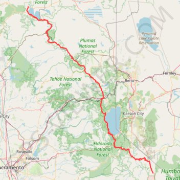
Import a GPX file

Chester - Walker

Vélo. En aller simple entre Chester et Walker. #Vélo

  • Distance: 238.5 mi
  • Elevation gain: 19,974 ft
  • Maximum elevation: 8,337 ft
  • Elevation loss: 19,140 ft
  • Minimum elevation: 2,933 ft
  • Moving time: 1 d 7 h
  • Moving speed: 7.6 mph
  • Maximum speed: 45.3 mph
  • Total time: 8 d 3 h
  • Global speed: 1.2 mph
  • Date: 07/19/2014

Interactive map

GPS track profile

About this GPS track

Other GPS tracks

Click on a GPS track to view route, its statistics and profile.

Lindsey Lake to Five Lakes Basin Loop

United States > California > Nevada County

Loop hike between Lindsey Lake and Five Lakes Basin via Carr-Lindsey Road, Middle Lindsey Dam, Culbertson Lake, Lindsey Lake Trail, Lower Rock Lake, Rock Lake, Crooked Lake Trail, Penner Lake, Crooked Lakes, Island Lake, Round Lake Trail, Long Lake, Round Lake, Milk Lake, Grouse Ridge Trail, Sand Ridge Trail, Sand Ridge, Five Lakes…

Distance: 23.5 mi • Elevation gain: 3,425 ft • Maximum elevation: 7,592 ft

Sugar Pine Reservoir Loop

United States > California > Placer County

Loop hike around the Sugar Pine Reservoir via Joshua M. Hardt Memorial Trail and Sugar Pine Dam in the Tahoe National Forest. #Hike #Loop #Lake #Mountain #Nature #Forest #Dam

Distance: 4.4 mi • Elevation gain: 528 ft • Maximum elevation: 3,717 ft

Five Lakes Loop

United States > California > Placer County > Alpine Meadows

Loop hike from Alpine Meadows to Five Lakes via Five Lakes Trail in the Granite Chief Wilderness and the Tahoe National Forest. #Hike #Loop #Lake #Mountain #Nature #Forest #Wilderness

Distance: 6.2 mi • Elevation gain: 1,437 ft • Maximum elevation: 7,602 ft

Wrights Lake and Enchanted Pools Loop

United States > California > El Dorado County

Loop hike from Wrights Lake via Twin Lakes Trail, Enchanted Pools, Tyler Lake Trail, Rockbound Trail and Old Corral Loop Trail in the Eldorado National Forest and the Desolation Wilderness. #Hike #Loop #Lake #Nature #Forest #Mountain #River #Falls #Wilderness

Distance: 4.0 mi • Elevation gain: 449 ft • Maximum elevation: 7,313 ft

Five Lakes Basin

United States > California > Nevada County

Hike to Five Lakes Basin via Grouse Ridge Trail, Glacier Lake Trail and Sand Ridge Trail in the Tahoe National Forest. #Hike #Mountain #Lake #Nature #Forest

Distance: 8.0 mi • Elevation gain: 1,506 ft • Maximum elevation: 7,493 ft

Upper Echo Lake and Lower Echo Lake

United States > California > El Dorado County > Echo Lake

Hike from Echo Lake to Upper Echo Lake and Lower Echo Lake via Echo Pass Viewpoint and Pacific Crest National Scenic Trail (PCT) in the Lake Tahoe Basin Management Unit. #Hike #Lake #Mountain #Nature #Forest #PCT #Overlook

Distance: 5.9 mi • Elevation gain: 896 ft • Maximum elevation: 7,635 ft

Cathedral Lake and Floating Island Lake

United States > California > El Dorado County > Spring Creek

Hike to Cathedral Lake and Floating Island Lake via Mount Tallac Trail above the Fallen Leaf Lake in the Desolation Wilderness. #Hike #Nature #Lake #Mountain #Forest #Wilderness

Distance: 5.5 mi • Elevation gain: 1,207 ft • Maximum elevation: 7,638 ft

Auburn State Recreation Area

United States > California > Placer County

Hike from Iowa Hill Road to Yankee Jims Bridge along the North Fork American River via Windy Point Trail and Indian Creek Trail in the Auburn State Recreation Area. #Hike #Nature #Mountain #River #Forest

Distance: 5.4 mi • Elevation gain: 1,263 ft • Maximum elevation: 1,673 ft

Mount Tallac

United States > California > El Dorado County > Spring Creek

Desolation Wilderness. Lake Tahoe, Fallen Leaf Lake, Floating Island Lake, Cathedral Lake. #Hike #Snowshoes #Mountain #Lake #Forest #Nature

Distance: 10.0 mi • Elevation gain: 3,327 ft • Maximum elevation: 9,708 ft

North Yuba River MTB Loop

United States > California > Sierra County > Goodyears Bar

Mountain Bike loop along the North Yuba River and on the Fiddle Creek Ridge in the Tahoe National Forest. #MTB #Loop #River #Canyon #Forest #Mountain #Nature

Distance: 19.9 mi • Elevation gain: 6,076 ft • Maximum elevation: 4,111 ft

North Fork American River via Stevens Trail

United States > California > Placer County

Tahoe National Forest. #Hike #River #Forest #Mountain #Forest #Waterfall #Nature #Tahoe

Distance: 7.7 mi • Elevation gain: 2,126 ft • Maximum elevation: 2,382 ft

Day 1: Home to dispersed camping 60 mi E of Austin, NV

United States > Nevada > Washoe County > Reno

Distance: 129.5 mi • Elevation gain: 3,320 ft • Maximum elevation: 5,128 ft

Eagle Lake via Upper Eagle Falls

United States > California > El Dorado County

Desolation Wilderness. #Hike #Lake #Waterfall #River #Forest #Mountain #Nature

Distance: 1.9 mi • Elevation gain: 443 ft • Maximum elevation: 7,018 ft

Walker - Auberry

États-Unis d'Amérique > Californie > Mono County > Walker

Vélo. En aller simple entre Walker et Auberry. #Vélo

Distance: 220.0 mi • Elevation gain: 21,762 ft • Maximum elevation: 9,970 ft

Jenkinson Lake Loop

United States > California > El Dorado County

Hike / Run / Mountain Bike loop around Jenkinson Lake, Pollock Pines. #Hike #Run #MTB #Loop #Lake #Forest #Nature

Distance: 8.1 mi • Elevation gain: 958 ft • Maximum elevation: 3,622 ft

Olmstead Loop Trail

United States > California > El Dorado County > Cool

Mountain Bike loop in Auburn State Recreation Area. #MTB #Loop #Forest #Nature

Distance: 9.3 mi • Elevation gain: 1,010 ft • Maximum elevation: 1,627 ft

Horsetail Falls

United States > California > El Dorado County > Twin Bridges

Desolation Wilderness. Eldorado National Forest. #Hike #Waterfall #River #Mountain #Forest #Nature

Distance: 4.0 mi • Elevation gain: 1,368 ft • Maximum elevation: 7,484 ft

Hidden Falls Loop

United States > California > Placer County

Hidden Falls Regional Park. Deadman Creek. #Hike #Loop #Waterfall #River #Forest #Nature

Distance: 3.3 mi • Elevation gain: 597 ft • Maximum elevation: 1,004 ft

Ashland - Chester

États-Unis d'Amérique > Oregon > Jackson County > Ashland

Vélo. En aller simple entre Ashland et Chester. #Vélo

Distance: 252.7 mi • Elevation gain: 18,691 ft • Maximum elevation: 8,533 ft

Kirkwood Meadows

United States > California > Alpine County

#Hike #Loop

Distance: 3.0 mi • Elevation gain: 217 ft • Maximum elevation: 7,815 ft

Red Peak

United States > California > El Dorado County

#Hike #Loop #Eldorado

Distance: 15.5 mi • Elevation gain: 3,209 ft • Maximum elevation: 9,219 ft