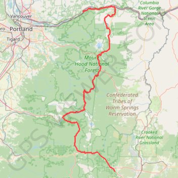
Cascade Locks - Sisters
Vélo. En aller simple entre Cascade Locks et Sisters. #Vélo
- Distance: 199.0 mi
- Elevation gain: 19,505 ft
- Maximum elevation: 4,823 ft
- Elevation loss: 16,381 ft
- Minimum elevation: 85 ft
- Moving time: 1 d 5 h
- Moving speed: 6.7 mph
- Maximum speed: 41.7 mph
- Total time: 6 d 11 h
- Global speed: 1.3 mph
- Date: 06/25/2014
Interactive map
GPS track profile
About this GPS track
Name: Cascade Locks - Sisters GPS track, route, trail
Coordinates: 44.25862 -122.15216 45.71081 -121.49633
Other GPS tracks
Click on a GPS track to view route, its statistics and profile.
Multnomah Falls, Ecola Falls and Wahkeena Falls Loop
United States > Oregon > Multnomah County
Loop hike via Larch Mountain Trail, Benson Bridge, Lower Multnomah Falls, Dutchman Falls, Wiesendanger Falls, Ecola Falls, Wahkeena Trail, Fairy Falls, Lemmons Viewpoint, Wahkeena Falls and Return Trail in the Mount Hood National Forest above the Benson Lake and the Columbia River. #Hike #Loop #Falls #River #Nature #Mountain #Forest…
Distance: 5.7 mi • Elevation gain: 3,419 ft • Maximum elevation: 1,660 ft
Northern part of the Pacific Crest Trail (PCT)
United States > Oregon > Klamath County
Hike on the Pacific Crest National Scenic Trail from Crater Lake to Canada Border through Oregon and Washington along the Sierra Nevada and Cascade mountain ranges. #Hike #Mountain #SierraNevada #Cascade #Nature #Forest #Park #PCT
Distance: 744.6 mi • Elevation gain: 145,367 ft • Maximum elevation: 7,569 ft
Eagle Creek and Falls
United States > Oregon > Hood River County
Hike from Columbia River to the Wahtum Lake along Eagle Creek via Metlako Falls, Sorenson Falls, Punch Bowl Falls, Four Mile Falls, Wy east Falls, Grand Union Falls, Tunnel Falls and Twister Falls in the Mark O. Hatfield Wilderness. #Hike #River #Falls #Canyon #Forest #Mountain #Lake #Wilderness
Distance: 13.1 mi • Elevation gain: 5,833 ft • Maximum elevation: 3,753 ft
Sisters - Ashland
États-Unis d'Amérique > Oregon > Deschutes County
Vélo. En aller simple entre Bend et Ashland. #Vélo
Distance: 294.4 mi • Elevation gain: 18,619 ft • Maximum elevation: 7,661 ft