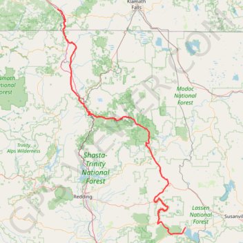
Ashland - Chester
Vélo. En aller simple entre Ashland et Chester. #Vélo
- Distance: 252.7 mi
- Elevation gain: 18,691 ft
- Maximum elevation: 8,533 ft
- Elevation loss: 16,211 ft
- Minimum elevation: 1,955 ft
- Moving time: 2 d 10 m
- Moving speed: 5.2 mph
- Maximum speed: 38.8 mph
- Total time: 7 d 8 h
- Global speed: 1.4 mph
- Date: 07/11/2014
Interactive map
GPS track profile
About this GPS track
Name: Ashland - Chester GPS track, route, trail
Coordinates: 40.25904 -122.67712 42.18273 -121.22476
Other GPS tracks
Click on a GPS track to view route, its statistics and profile.
Cinder Cone Trail
United States > California > Lassen County
Distance: 4.7 mi • Elevation gain: 1,070 ft • Maximum elevation: 6,834 ft
Chester - Walker
États-Unis d'Amérique > Californie > Plumas County > Chester
Vélo. En aller simple entre Chester et Walker. #Vélo
Distance: 238.5 mi • Elevation gain: 19,974 ft • Maximum elevation: 8,337 ft
Sisters - Ashland
États-Unis d'Amérique > Oregon > Deschutes County
Vélo. En aller simple entre Bend et Ashland. #Vélo
Distance: 294.4 mi • Elevation gain: 18,619 ft • Maximum elevation: 7,661 ft