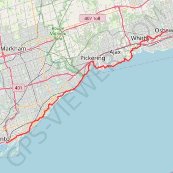
GPS tracks visualization and sharing, free and without registration.
#Bike
Canada > Quebec > Québec (Agglomération) > Quebec City
Distance: 670.1 mi - Elevation gain: 15,902 ft - Maximum elevation: 682 ft - Coordinates: 43.08778 -79.89248 46.82520 -71.19960
Start: 114, 10e Rue, Limoilou, Vieux-Limoilou, La Cité-Limoilou, Quebec City, Québec (Agglomération), Capitale-Nationale, Quebec, G1L 2X2, Canada (46.82514 -71.23278)
End: Military Road, Pletchers Corners, Niagara Town, Niagara County, New York, 14092, United States (43.11863 -78.99575)
Lake Ontario. #Hike #Loop #Ontario #Toronto #Niagara
Distance: 182.6 mi - Elevation gain: 5,413 ft - Maximum elevation: 663 ft - Coordinates: 43.07349 -79.82924 43.65818 -79.04493
Start: The Arts & Letters Club of Toronto, 14, Elm Street, Discovery District, University—Rosedale, Toronto, Golden Horseshoe, Ontario, M5G 1G7, Canada (43.65818 -79.38256)
End: 655, Bay Street, Discovery District, University—Rosedale, Toronto, Golden Horseshoe, Ontario, M5G 2K4, Canada (43.65792 -79.38344)
#Hike #Run #SerenaGundy
Distance: 0.8 mi - Elevation gain: 98 ft - Maximum elevation: 423 ft - Coordinates: 43.71816 -79.35975 43.71957 -79.35473
Start: Serena Gundy Park Trail, Don Valley West, East York, Toronto, Golden Horseshoe, Ontario, M4G 2L8, Canada (43.71957 -79.35493)
Canada > Ontario > Durham Region > Pickering
Distance: 50.1 mi - Elevation gain: 1,959 ft - Maximum elevation: 423 ft - Coordinates: 43.79465 -79.11770 43.91711 -78.43903
Start: 309, Dyson Road, Rosebank Station, Pickering, Durham Region, Golden Horseshoe, Ontario, L1W 2B2, Canada (43.79465 -79.11770)
End: 1001, Lakeshore Road, Port Hope, Northumberland County, Central Ontario, Ontario, Canada (43.91711 -78.43907)
Canada > Ontario > Durham Region > Pickering
Rouge National Park. #Hike #Run #Loop #Rouge
Distance: 3.2 mi - Elevation gain: 249 ft - Maximum elevation: 456 ft - Coordinates: 43.81388 -79.17186 43.82634 -79.15313
Start: Twyn Rivers Drive, Scarborough—Rouge Park, Scarborough, Pickering, Durham Region, Golden Horseshoe, Ontario, L1V 6M9, Canada (43.81419 -79.15370)
Canada > Ontario > Peel Region > Mississauga
Lake Ontario. #Bike #Brampton #Scarborough #Toronto #Ontario
Distance: 45.5 mi - Elevation gain: 1,864 ft - Maximum elevation: 604 ft - Coordinates: 43.62986 -79.63545 43.80958 -79.11634
Start: Indian Line Campground, Wildfern Drive, Malton, Mississauga, Peel Region, Golden Horseshoe, Ontario, L4T 3V9, Canada (43.73573 -79.63545)
End: Glen Rouge Campground, 7450, Kingston Road, Scarborough—Rouge Park, Scarborough, Toronto, Golden Horseshoe, Ontario, M1B 5S3, Canada (43.80566 -79.13719)
Lake Ontario. #Bike #Toronto #Ontario
Distance: 25.3 mi - Elevation gain: 807 ft - Maximum elevation: 358 ft - Coordinates: 43.60218 -79.49846 43.71651 -79.28622
Start: Don Trail, Don Valley East, North York, Toronto, Golden Horseshoe, Ontario, M4H 1E7, Canada (43.71648 -79.34936)
End: 18, First Street, Lakeshore Village, Etobicoke—Lakeshore, Etobicoke, Toronto, Golden Horseshoe, Ontario, M8V 2W2, Canada (43.60218 -79.49846)
Lake Ontario. #Bike #Scarborough #Cobourg #Toronto #Ontario
Distance: 66.7 mi - Elevation gain: 2,392 ft - Maximum elevation: 427 ft - Coordinates: 43.79682 -79.13725 43.97058 -78.16448
Start: Glen Rouge Campground, 7450, Kingston Road, Scarborough—Rouge Park, Scarborough, Toronto, Golden Horseshoe, Ontario, M1B 5S3, Canada (43.80566 -79.13719)
End: 156, Division Street, Cobourg, Northumberland County, Central Ontario, Ontario, K9A 0B3, Canada (43.95763 -78.16448)
Distance: 7.2 mi - Elevation gain: 203 ft - Maximum elevation: 351 ft - Coordinates: 43.64892 -79.36587 43.71608 -79.33334
Start: 972, Eglinton Avenue East, Leaside Business Park, Don Valley West, East York, Toronto, Golden Horseshoe, Ontario, M4G 2L8, Canada (43.71608 -79.35289)
End: 60, Distillery Lane, Distillery District, Spadina—Fort York, Toronto, Golden Horseshoe, Ontario, M5A 3C4, Canada (43.64892 -79.35845)
#Bike
Distance: 50.5 mi - Elevation gain: 1,673 ft - Maximum elevation: 371 ft - Coordinates: 43.25293 -79.89248 43.64847 -79.35831
Start: Days Inn, Main Street East, Corktown, Hamilton, Golden Horseshoe, Ontario, L9T 1P7, Canada (43.25293 -79.86125)
End: Martin Goodman Trail, Spadina—Fort York, Toronto, Golden Horseshoe, Ontario, M5A 3C4, Canada (43.64847 -79.35831)
Lake Ontario. High Park. #Bike #Loop #High #Ontario #Toronto
Distance: 17.1 mi - Elevation gain: 591 ft - Maximum elevation: 427 ft - Coordinates: 43.62986 -79.46805 43.66831 -79.35118
Start: Sunnyside Pavillion, Martin Goodman Trail, Parkdale—High Park, Toronto, Golden Horseshoe, Ontario, M6S, Canada (43.63794 -79.45641)
Distance: 8.9 mi - Elevation gain: 305 ft - Maximum elevation: 597 ft - Coordinates: 43.65880 -79.46535 43.70476 -79.34983
Start: 49, Croham Road, Eglinton—Lawrence, York, Toronto, Golden Horseshoe, Ontario, M6E 4Y2, Canada (43.69439 -79.46471)
End: 692, Queen Street East, Toronto—Danforth, Toronto, Golden Horseshoe, Ontario, M4M 2G1, Canada (43.65880 -79.35049)