Red Peak
Interactive map
GPS track profile
About this GPS track
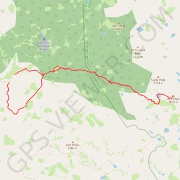
Name: Red Peak GPS track, route, trail
Start: Forest Service Road 36, El Dorado County, California, United States (38.93135 -120.32125)
End: Forest Service Road 36, El Dorado County, California, United States (38.93546 -120.31803)
Coordinates: 38.91665 -120.32284 38.93937 -120.22133
Topography: El Dorado County topographic map
Other GPS tracks
Click on a GPS track to view route, its statistics and profile.
Chester - Walker
États-Unis d'Amérique > Californie > Plumas County > Chester
Vélo. En aller simple entre Chester et Walker. #Vélo
Distance: 238.5 mi • Elevation gain: 19,974 ft • Maximum elevation: 8,337 ft