Sentosa Park
Interactive map
GPS track profile
About this GPS track
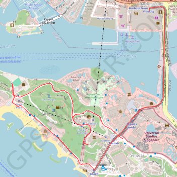
Name: Sentosa Park GPS track, route, trail
End: Artillery Avenue, Southern Islands, Singapore, Southwest, 098588, Singapore (1.25397 103.82025)
Coordinates: 1.25130 103.81087 1.26516 103.82380
Other GPS tracks
Click on a GPS track to view route, its statistics and profile.
Kualanamu International Airport to Jakarta, Indonesia
Indonésie > Sumatra du Nord > Deli Serdang > Beringin
Distance: 1,124.2 mi • Elevation gain: 36,014 ft • Maximum elevation: 410 ft
Labrador Park
Singapore > Central > Singapore
#Hike
Distance: 5.0 mi • Elevation gain: 299 ft • Maximum elevation: 89 ft
Pipeline TGI by AGM
Indonesia > South Sumatra > Tungkal Jaya > Beji Mulyo
Distance: 330.2 mi • Elevation gain: 5,932 ft • Maximum elevation: 318 ft