The Green Corridor - Singapore
#Hike
- Distance: 13.8 mi
- Elevation gain: 548 ft
- Maximum elevation: 144 ft
- Elevation loss: 512 ft
- Minimum elevation: 23 ft
Interactive map
GPS track profile
About this GPS track
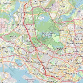
Name: The Green Corridor - Singapore GPS track, route, trail
Start: Woodlands Road, Sungei Kadut, Singapore, Northwest, 738782, Singapore (1.43391 103.76055)
End: Rail Corridor, Radin Mas, Bukit Merah, Singapore, Central, 159836, Singapore (1.27638 103.82891)
Coordinates: 1.27569 103.75245 1.43391 103.82901
Other GPS tracks
Click on a GPS track to view route, its statistics and profile.
Bukit Timah Hill - MacRitchie Reservoir
Singapore > Southwest > Singapore
#Hike
Distance: 9.2 mi • Elevation gain: 951 ft • Maximum elevation: 548 ft
Singapore Botanical Gardens
Distance: 6.6 mi • Elevation gain: 528 ft • Maximum elevation: 131 ft
Directions from Duck Tour Ramp to Marina Boulevard, Singapore
Singapore > Central > Singapore
Distance: 65.5 mi • Elevation gain: 2,664 ft • Maximum elevation: 167 ft
Singapore Botanical Gardens.gpx
Singapore > Central > Singapore
Distance: 6.6 mi • Elevation gain: 528 ft • Maximum elevation: 131 ft
Singapore Botanical Gardens
Singapore > Central > Singapore
Distance: 6.6 mi • Elevation gain: 528 ft • Maximum elevation: 131 ft
Kualanamu International Airport to Jakarta, Indonesia
Indonésie > Sumatra du Nord > Deli Serdang > Beringin
Distance: 1,124.2 mi • Elevation gain: 36,014 ft • Maximum elevation: 410 ft