Labrador Park
#Hike
- Distance: 5.0 mi
- Elevation gain: 299 ft
- Maximum elevation: 89 ft
- Elevation loss: 253 ft
- Minimum elevation: -3 ft
Interactive map
GPS track profile
About this GPS track
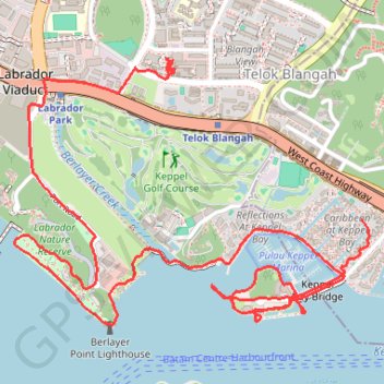
Name: Labrador Park GPS track, route, trail
Start: 4, Telok Blangah Road, Bukit Merah, Singapore, Central, 098402, Singapore (1.26692 103.81584)
End: 79, Telok Blangah Drive, Bukit Merah, Singapore, Southwest, 100079, Singapore (1.27344 103.80757)
Coordinates: 1.26247 103.80105 1.27379 103.81616
Other GPS tracks
Click on a GPS track to view route, its statistics and profile.
Directions from Duck Tour Ramp to Marina Boulevard, Singapore
Singapore > Central > Singapore
Distance: 65.5 mi • Elevation gain: 2,664 ft • Maximum elevation: 167 ft
Kualanamu International Airport to Jakarta, Indonesia
Indonésie > Sumatra du Nord > Deli Serdang > Beringin
Distance: 1,124.2 mi • Elevation gain: 36,014 ft • Maximum elevation: 410 ft