Singapore
#Hike
- Distance: 4.8 mi
- Elevation gain: 397 ft
- Maximum elevation: 79 ft
- Elevation loss: 374 ft
- Minimum elevation: 3 ft
Interactive map
GPS track profile
About this GPS track
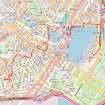
Name: Singapore GPS track, route, trail
Coordinates: 1.27649 103.83932 1.28964 103.86132
Other GPS tracks
Click on a GPS track to view route, its statistics and profile.
Directions from Duck Tour Ramp to Marina Boulevard, Singapore
Singapore > Central > Singapore
Distance: 65.5 mi • Elevation gain: 2,664 ft • Maximum elevation: 167 ft
Singapore East Coast Park
Singapore > Southeast > Singapore
#Hike
Distance: 7.8 mi • Elevation gain: 259 ft • Maximum elevation: 72 ft
Kualanamu International Airport to Jakarta, Indonesia
Indonésie > Sumatra du Nord > Deli Serdang > Beringin
Distance: 1,124.2 mi • Elevation gain: 36,014 ft • Maximum elevation: 410 ft