Import a GPX file

Salaberry-de-Valleyfield - Montréal

#Bike

  • Distance: 55.9 mi
  • Elevation gain: 1,191 ft
  • Maximum elevation: 230 ft
  • Elevation loss: 1,194 ft
  • Minimum elevation: 56 ft

Interactive map

GPS track profile

About this GPS track
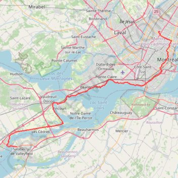
Other GPS tracks

Click on a GPS track to view route, its statistics and profile.

Montréal - New York

Canada > Quebec > Urban agglomeration of Montreal > Montreal

#Bike #Montréal #NewYork

Distance: 396.2 mi • Elevation gain: 15,945 ft • Maximum elevation: 988 ft

Parc Maisonneuve et jardin botanique de Montréal

Canada > Québec > Agglomération de Montréal > Montréal

Randonnée / course à pied en boucle par le parc Maisonneuve et jardin botanique de Montréal. #Randonnée #Course #Boucle #Parc #Nature #Forêt #Ville

Distance: 6.6 mi • Elevation gain: 203 ft • Maximum elevation: 223 ft

Base

Canada > Québec > Agglomération de Montréal > Montréal

Objectif 139 bpm pendant 46 minutes.

Distance: 6.5 mi • Elevation gain: 141 ft • Maximum elevation: 197 ft

Montréal - Westmount

Canada > Quebec > Urban agglomeration of Montreal > Montreal

#Bike #Montréal

Distance: 8.5 mi • Elevation gain: 108 ft • Maximum elevation: 197 ft

Oka - Montréal

Canada > Quebec > Deux-Montagnes (MRC) > Oka

#Bike #Montréal

Distance: 40.6 mi • Elevation gain: 879 ft • Maximum elevation: 167 ft

Montréal - Lanoraie

Canada > Quebec > Urban agglomeration of Montreal > Montreal

Saint Lawrence River. #Bike #Montréal #Lanoraie #SaintLawrence

Distance: 43.6 mi • Elevation gain: 594 ft • Maximum elevation: 171 ft

Montréal - Vaudreuil-Dorion

Canada > Québec > Vaudreuil-Soulanges > Vaudreuil-Dorion

#Vélo

Distance: 29.1 mi • Elevation gain: 322 ft • Maximum elevation: 305 ft

Québec - Montréal - Saint-Laurent River - Lake Ontario - Niagara Falls

Canada > Quebec > Urban agglomeration of Québec > Quebec

#Bike #Ontario

Distance: 670.1 mi • Elevation gain: 15,761 ft • Maximum elevation: 686 ft

Jardin botanique de Montréal

Canada > Québec > Agglomération de Montréal > Montréal

Course à pied dans le jardin botanique de Montréal. #Course #Running #Boucle #Nature #Ville #Parc #Forêt

Distance: 6.3 mi • Elevation gain: 102 ft • Maximum elevation: 213 ft

Grenville-sur-la-Rouge - Montréal

Canada > Quebec > Argenteuil > Grenville-sur-la-Rouge

Ottawa River. #Bike #Montréal

Distance: 77.8 mi • Elevation gain: 1,742 ft • Maximum elevation: 302 ft

Montréal - New York

Canada > Québec > Agglomération de Montréal > Montréal

Distance: 396.0 mi • Elevation gain: 13,563 ft • Maximum elevation: 988 ft

East Hawkesbury - Montréal

Canada > Ontario > Prescott and Russell Counties > East Hawkesbury

#Bike #EastHawkesbury #Montréal

Distance: 56.8 mi • Elevation gain: 1,289 ft • Maximum elevation: 299 ft

Pierreville - Leclercville

Canada > Quebec > Urban agglomeration of Montreal > Montreal

#Bike #Pierreville #Leclercville #Atlantic

Distance: 75.1 mi • Elevation gain: 1,063 ft • Maximum elevation: 118 ft

Cornwall - Salaberry-de-Valleyfield

Canada > Ontario > Cornwall > Cornwall

#Bike

Distance: 40.0 mi • Elevation gain: 472 ft • Maximum elevation: 210 ft

Lancaster - Montréal

Canada > Ontario > Stormont, Dundas and Glengarry Counties > South Glengarry > South Lancaster

#Bike #Lancaster #Montréal

Distance: 60.0 mi • Elevation gain: 876 ft • Maximum elevation: 171 ft

Arboretum Morgan Yellow Trail

Canada > Quebec > Urban agglomeration of Montreal > Sainte-Anne-de-Bellevue

#Hike #Snowshoes #Ski

Distance: 2.8 mi • Elevation gain: 108 ft • Maximum elevation: 184 ft