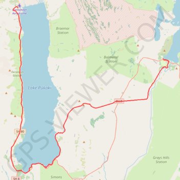
Lake Tekapo - Lake Pukaki - Glenntanner
#Bike
- Distance: 49.6 mi
- Elevation gain: 1,985 ft
- Maximum elevation: 2,464 ft
- Elevation loss: 2,507 ft
- Minimum elevation: 1,745 ft
Interactive map
GPS track profile
About this GPS track
Name: Lake Tekapo - Lake Pukaki - Glenntanner GPS track, route, trail
Coordinates: -44.19095 170.10816 -43.91216 170.47621
Other GPS tracks
Click on a GPS track to view route, its statistics and profile.