Lesotho - Semonkong
Interactive map
GPS track profile
About this GPS track
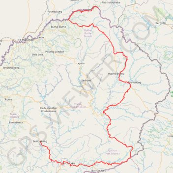
Name: Lesotho - Semonkong GPS track, route, trail
End: A5, Maheletoane (Semonkoaneng), Semonkong, Maseru District, Lesotho (-29.84053 28.05309)
Coordinates: -30.07824 28.05308 -28.57545 29.05633
Other GPS tracks
Click on a GPS track to view route, its statistics and profile.
Grande traversée du Drakensberg
Afrique du Sud > KwaZulu-Natal > Uthukela District Municipality > Okhahlamba Local Municipality
#Randonnée #Drakensberg #Lesotho
Distance: 127.8 mi • Elevation gain: 24,652 ft • Maximum elevation: 11,309 ft
Chain Ladder Path
Afrique du Sud > État-Libre > Thabo Mofutsanyana District Municipality > Maluti-a-Phofung Local Municipality
Distance: 2.9 mi • Elevation gain: 2,044 ft • Maximum elevation: 9,862 ft
Thukela Falls - Sentinel
South Africa > Free State > Thabo Mofutsanyana District Municipality > Maluti-a-Phofung Local Municipality
#Hike
Distance: 7.9 mi • Elevation gain: 3,291 ft • Maximum elevation: 9,862 ft