Saint Arnaud - Murchison
Interactive map
GPS track profile
About this GPS track
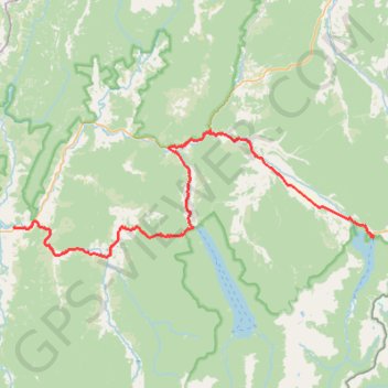
Name: Saint Arnaud - Murchison GPS track, route, trail
Start: Kerr Bay Campsite, Lake Road, Saint Arnaud, Tasman, 7072, New Zealand (-41.80587 172.84745)
End: Riverview Holiday Park, Riverview Road, Murchison, Tasman, 7007, New Zealand (-41.79590 172.34090)
Coordinates: -41.82681 172.34023 -41.69414 172.84745
Other GPS tracks
Click on a GPS track to view route, its statistics and profile.
Murchison - Reefton
New Zealand > Tasman > Tasman District > Murchison
#Bike
Distance: 75.9 mi • Elevation gain: 5,991 ft • Maximum elevation: 2,260 ft