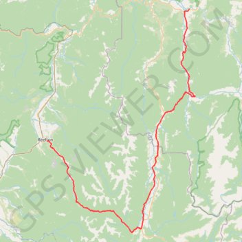
Murchison - Reefton
#Bike
- Distance: 75.9 mi
- Elevation gain: 5,991 ft
- Maximum elevation: 2,260 ft
- Elevation loss: 5,896 ft
- Minimum elevation: 554 ft
Interactive map
GPS track profile
About this GPS track
Name: Murchison - Reefton GPS track, route, trail
End: 14, Broadway, Reefton, Buller District, West Coast, 7830, New Zealand (-42.11981 171.86990)
Coordinates: -42.34506 171.86990 -41.79520 172.35985
Other GPS tracks
Click on a GPS track to view route, its statistics and profile.