GPS tracks, routes, trails, hikes

GPS tracks visualization and sharing, free and without registration.

Import a GPX file

Sydney

#Hike #Loop #Sydney

  • Distance: 9.2 mi
  • Elevation gain: 1,522 ft
  • Maximum elevation: 315 ft
  • Elevation loss: 1,526 ft
  • Minimum elevation: 0 ft

Interactive map

GPS track profile

About this GPS track

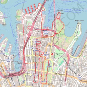
Name: Sydney GPS track, route, trail.
Start: The Rocks, Sydney, Council of the City of Sydney, New South Wales, 2000, Australia (-33.86110 151.20967)
End: Sydney, Council of the City of Sydney, New South Wales, 2000, Australia (-33.86114 151.21021)
Coordinates: -33.87687 151.20258 -33.85366 151.21697

Other GPS tracks

Royal Botanic Garden

Australie > Nouvelle Galles du Sud > Sydney

Distance: 0.7 mi - Elevation gain: 56 ft - Maximum elevation: 75 ft - Total time: 21 m 54 s - Date: 12/31/2009 - Coordinates: -33.86536 151.21524 -33.86195 151.21876

Start: Royal Botanic Garden, Mrs Macquaries Road, Sydney, Council of the City of Sydney, Nouvelle Galles du Sud, 2000, Australie (-33.86195 151.21537)

Sydney Sightseer

Australia > New South Wales > Sydney

#Bike #Loop #Sydney

Distance: 32.5 mi - Elevation gain: 2,890 ft - Maximum elevation: 312 ft - Coordinates: -33.90670 151.17565 -33.83946 151.28690

Start: Jubilee Oval, Victoria Road, Glebe, Sydney, Council of the City of Sydney, Inner West, New South Wales, 2037, Australia (-33.87384 151.17713)

End: Federal Park Skate Park, Chapman Road, Annandale, Sydney, Council of the City of Sydney, New South Wales, 2039, Australia (-33.87402 151.17568)

Royal Botanic Park - Sydney

Australia > New South Wales > Sydney

#Hike #Loop

Distance: 8.8 mi - Elevation gain: 1,234 ft - Maximum elevation: 226 ft - Coordinates: -33.87674 151.20965 -33.85631 151.22254

Start: Sydney, Council of the City of Sydney, New South Wales, 2000, Australia (-33.85893 151.21352)

End: Bennelong Apartments, Macquarie Street, Sydney, Council of the City of Sydney, New South Wales, 2000, Australia (-33.85902 151.21315)

Centennial Park - Sydney

Australia > New South Wales > Sydney

#Bike #Centennial #Sydney

Distance: 18.3 mi - Elevation gain: 1,158 ft - Maximum elevation: 246 ft - Coordinates: -33.90480 151.19141 -33.85820 151.24119

Start: Carriageworks, 245, Wilson Street, Eveleigh, Sydney, Council of the City of Sydney, New South Wales, 2015, Australia (-33.89338 151.19141)

End: 88, Cumberland Street, Dawes Point, Sydney, Council of the City of Sydney, New South Wales, 2000, Australia (-33.85820 151.20750)