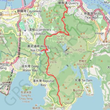
Wilson Trail
#Hike
- Distance: 8.1 mi
- Elevation gain: 3,386 ft
- Maximum elevation: 1,345 ft
- Elevation loss: 3,189 ft
- Minimum elevation: 85 ft
Interactive map
GPS track profile
About this GPS track
Name: Wilson Trail GPS track, route, trail
Coordinates: 22.22368 114.19483 22.28604 114.21338
Other GPS tracks
Click on a GPS track to view route, its statistics and profile.
雙潭渣大
China > Hong Kong > Hong Kong Island
Distance: 4.2 mi • Elevation gain: 1,158 ft • Maximum elevation: 1,001 ft
Hong Kong island ride
China > Hong Kong > Hong Kong Island
#Bike
Distance: 38.4 mi • Elevation gain: 7,060 ft • Maximum elevation: 1,657 ft
Wilson Trail Full Route
China > Hong Kong > Hong Kong Island
Distance: 50.5 mi • Elevation gain: 14,534 ft • Maximum elevation: 2,011 ft
Jardine's Lookout
China > Hong Kong > Hong Kong Island
#Hike
Distance: 3.8 mi • Elevation gain: 1,148 ft • Maximum elevation: 1,345 ft
Trail Planner Map
China > Hong Kong > Hong Kong Island
Distance: 12.6 mi • Elevation gain: 3,776 ft • Maximum elevation: 1,388 ft
Parview - Mont Butler - Reservoirs - Repulse Bay
Chine > Hong Kong > Île de Hong Kong
Randonnée pédestre. En aller simple. #Randonnée
Distance: 5.2 mi • Elevation gain: 1,253 ft • Maximum elevation: 1,345 ft