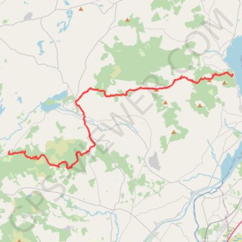
Feenlee Mountain - Moylussa - Cragnamurragh - Knockanuarha
From Twomilegate. #Hike
- Distance: 18.4 mi
- Elevation gain: 3,196 ft
- Maximum elevation: 1,732 ft
- Elevation loss: 3,123 ft
- Minimum elevation: 105 ft
Interactive map
GPS track profile
About this GPS track
Name: Feenlee Mountain - Moylussa - Cragnamurragh - Knockanuarha GPS track, route, trail
Coordinates: 52.76993 -8.71879 52.83599 -8.46428
Other GPS tracks
Click on a GPS track to view route, its statistics and profile.
Trace IRELAND
Distance: 936.2 mi • Elevation gain: 43,829 ft • Maximum elevation: 1,719 ft
RT5-1 Rosslare - Kinsale
Distance: 1,777.3 mi • Elevation gain: 89,833 ft • Maximum elevation: 1,378 ft
RT5-1 Rosslare - Kinsale
Distance: 2,402.9 mi • Elevation gain: 118,488 ft • Maximum elevation: 1,719 ft
RT5-1 Rosslare - Kinsale
Distance: 841.0 mi • Elevation gain: 50,016 ft • Maximum elevation: 1,378 ft