PR-G 27 Rota de Queguas
- Distance: 3.8 mi
- Elevation gain: 860 ft
- Maximum elevation: 3,724 ft
- Elevation loss: 860 ft
- Minimum elevation: 2,904 ft
Interactive map
GPS track profile
About this GPS track
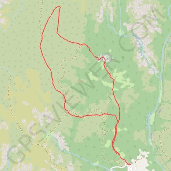
Name: PR-G 27 Rota de Queguas GPS track, route, trail
Start: Queguas, Venceáns, Entrimo, A Baixa Limia, Ourense, Galice, 32868, Espagne (41.97121 -8.10692)
End: Queguas, Venceáns, Entrimo, A Baixa Limia, Ourense, Galice, 32868, Espagne (41.97121 -8.10692)
Coordinates: 41.97121 -8.12207 41.99084 -8.10692
Other GPS tracks
Click on a GPS track to view route, its statistics and profile.
Southern section — European Divide Trail
France > Auvergne-Rhône-Alpes > Drôme > Valence
Distance: 1,506.1 mi • Elevation gain: 139,026 ft • Maximum elevation: 6,578 ft
Eurovelo 01 Spain + Portugal
France > Nouvelle-Aquitaine > Pyrénées-Atlantiques > Hendaye
Distance: 1,930.7 mi • Elevation gain: 100,367 ft • Maximum elevation: 4,931 ft
Volta Nortenha - Maia / Valença / Gerês / Bragança / Mogadou...
Distance: 554.7 mi • Elevation gain: 86,745 ft • Maximum elevation: 4,888 ft
Stage 26: Valence to Saint-Jean-de-Fos — European Divide Trail
France > Auvergne-Rhône-Alpes > Drôme > Valence
Distance: 1,506.1 mi • Elevation gain: 139,026 ft • Maximum elevation: 6,578 ft
De Villeneuve-sur-Lot à Guimarães
France > Nouvelle-Aquitaine > Lot-et-Garonne > Villeneuve-sur-Lot
Distance: 1,257.8 mi • Elevation gain: 72,575 ft • Maximum elevation: 4,393 ft
18/10/2020 12:05:36
Espagne > Pays basque autonome > Basse-Bidassoa > Fontarrabie
18/10/2020 12:05:36
Distance: 1,097.2 mi • Elevation gain: 107,316 ft • Maximum elevation: 5,272 ft