McKenzie Bight - Cascade Falls
Gowlland Tod Provincial Park. #Hike #GowllandTod
- Distance: 2.1 mi
- Elevation gain: 525 ft
- Maximum elevation: 492 ft
- Elevation loss: 525 ft
- Minimum elevation: 36 ft
Interactive map
GPS track profile
About this GPS track
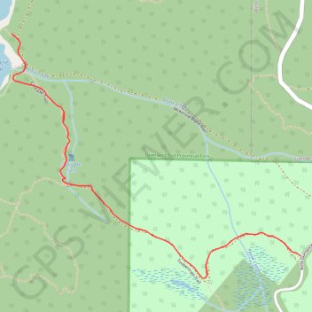
Name: McKenzie Bight - Cascade Falls GPS track, route, trail
Coordinates: 48.54793 -123.50509 48.55519 -123.49217
Other GPS tracks
Click on a GPS track to view route, its statistics and profile.
Mount Work - Mount Stewart - Thetis Lake
Canada > British Columbia > Capital Regional District > Highlands
#Hike
Distance: 12.6 mi • Elevation gain: 2,287 ft • Maximum elevation: 1,430 ft