Round Top - Sutton Trail
Interactive map
GPS track profile
About this GPS track
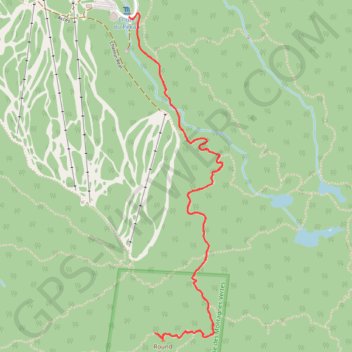
Name: Round Top - Sutton Trail GPS track, route, trail
Start: 582, Chemin Réal, Sutton, Brome-Missisquoi, Estrie, Quebec, J0E 1B0, Canada (45.09695 -72.54884)
End: 582, Chemin Réal, Sutton, Brome-Missisquoi, Estrie, Quebec, J0E 1B0, Canada (45.09695 -72.54884)
Coordinates: 45.08089 -72.54884 45.09712 -72.54227
Other GPS tracks
Click on a GPS track to view route, its statistics and profile.
Round Top - Sutton Trail
Canada > Quebec > Brome-Missisquoi > Sutton
https://en-hk.gps-viewer.com/track-hk4mt/Round-Top-Sutton-Trail/
Distance: 3.8 mi • Elevation gain: 1,385 ft • Maximum elevation: 3,097 ft
Round Top and Spruce Lake Loop
Canada > Québec > Brome-Missisquoi > Sutton
Distance: 4.4 mi • Elevation gain: 1,404 ft • Maximum elevation: 3,097 ft