Faro de Anaga
Benijo - Roque Bermejo. #Randonnée
- Distance: 4.4 mi
- Elevation gain: 2,211 ft
- Maximum elevation: 1,014 ft
- Elevation loss: 1,729 ft
- Minimum elevation: 233 ft
Interactive map
GPS track profile
About this GPS track
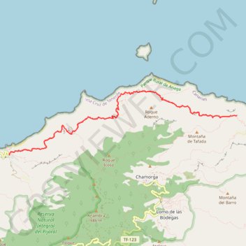
Name: Faro de Anaga GPS track, route, trail
Coordinates: 28.57390 -16.18775 28.58566 -16.14019
Other GPS tracks
Click on a GPS track to view route, its statistics and profile.
Anaga : Chamorga - Faro de Anago
Espagne > Santa Cruz de Ténérife
Distance: 4.8 mi • Elevation gain: 2,156 ft • Maximum elevation: 2,008 ft