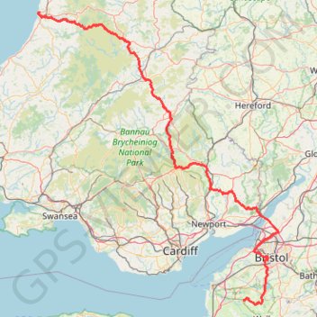
TT22 Jo10 M8/06 : Aberystwyth à Cheddar
- Distance: 153.7 mi
- Elevation gain: 12,710 ft
- Maximum elevation: 1,690 ft
- Elevation loss: 12,713 ft
- Minimum elevation: 0 ft
Interactive map
GPS track profile
About this GPS track
Name: TT22 Jo10 M8/06 : Aberystwyth à Cheddar GPS track, route, trail
Start: Parc y Bryn, Aberystwyth, Ceredigion, Pays de Galles, SY23 2AD, Royaume-Uni (52.41717 -4.07886)
End: Frog Cottage, Cliff Street, Cheddar, Somerset, Angleterre, BS27 3PX, Royaume-Uni (51.27935 -2.77400)
Coordinates: 51.26340 -4.08529 52.41717 -2.55225
Other GPS tracks
Click on a GPS track to view route, its statistics and profile.
2024-03-30_10-35_Sat
United Kingdom > England > City of Bristol > Bristol
Distance: 13.3 mi • Elevation gain: 656 ft • Maximum elevation: 194 ft
Cardiff Bay Trail
United Kingdom > Wales > Cardiff > Cardiff
Distance: 5.9 mi • Elevation gain: 226 ft • Maximum elevation: 56 ft
Dean2023-311
United Kingdom > England > Oxfordshire > Oxford
Distance: 192.8 mi • Elevation gain: 11,043 ft • Maximum elevation: 951 ft
TT22 J9 M7/06 : Heysham Port à Aberystwyth
Royaume-Uni > Angleterre > Lancashire > Lancaster > Morecambe
Distance: 215.9 mi • Elevation gain: 13,264 ft • Maximum elevation: 1,375 ft
TT22 Jo11 J9/06 : Cheddar à Plymouth Ferry Terminal
Royaume-Uni > Angleterre > Somerset > Cheddar
Distance: 166.7 mi • Elevation gain: 13,681 ft • Maximum elevation: 1,503 ft