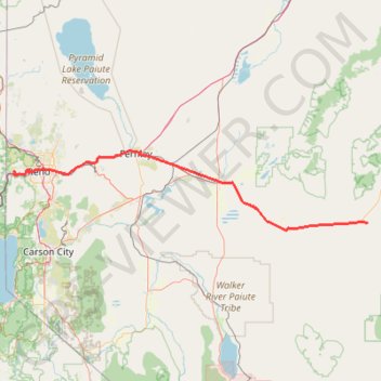
Day 1: Home to dispersed camping 60 mi E of Austin, NV
- Distance: 129.5 mi
- Elevation gain: 3,320 ft
- Maximum elevation: 5,128 ft
- Elevation loss: 3,389 ft
- Minimum elevation: 3,921 ft
Interactive map
GPS track profile
About this GPS track
Name: Day 1: Home to dispersed camping 60 mi E of Austin, NV GPS track, route, trail
Start: 9177, Bay Meadows Drive, Reno, Washoe County, Nevada, 89523, United States (39.52770 -119.95025)
End: Carroll Summit Road, Eastgate, Churchill County, Nevada, United States (39.29861 -117.91186)
Coordinates: 39.26428 -119.95114 39.61816 -117.91166
Topography: Reno topographic map
Other GPS tracks
Click on a GPS track to view route, its statistics and profile.
Chester - Walker
États-Unis d'Amérique > Californie > Plumas County > Chester
Vélo. En aller simple entre Chester et Walker. #Vélo
Distance: 238.5 mi • Elevation gain: 19,974 ft • Maximum elevation: 8,337 ft