London Marathon
- Distance: 26.2 mi
- Elevation gain: 922 ft
- Maximum elevation: 164 ft
- Elevation loss: 1,017 ft
- Minimum elevation: 3 ft
Interactive map
GPS track profile
About this GPS track
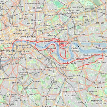
Name: London Marathon GPS track, route, trail
Coordinates: 51.47510 -0.14008 51.51283 0.06256
Topography: London topographic map
Other GPS tracks
Click on a GPS track to view route, its statistics and profile.
Green Link Walk from Smithfield Market to end at Pekham
United Kingdom > England > City of London
Distance: 5.4 mi • Elevation gain: 135 ft • Maximum elevation: 112 ft
Newhaven Londres
Royaume-Uni > Angleterre > Cité de Londres
Vélo. En aller simple entre Londres et Newhaven. #Vélo
Distance: 96.7 mi • Elevation gain: 3,737 ft • Maximum elevation: 663 ft
London Marathon
Royaume-Uni > Angleterre > Londres
Distance: 26.2 mi • Elevation gain: 784 ft • Maximum elevation: 161 ft