ELATI-ANTHIRO-MONH SPHLIAS-DRAKOTRYPA-ELATI
- Distance: 100.0 mi
- Elevation gain: 24,606 ft
- Maximum elevation: 5,738 ft
- Elevation loss: 24,606 ft
- Minimum elevation: 1,056 ft
Interactive map
GPS track profile
About this GPS track
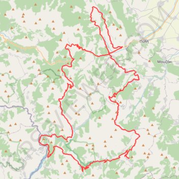
Name: ELATI-ANTHIRO-MONH SPHLIAS-DRAKOTRYPA-ELATI GPS track, route, trail
Coordinates: 39.25646 21.41352 39.51173 21.61446
Topography: Trikala Regional Unit topographic map
Other GPS tracks
Click on a GPS track to view route, its statistics and profile.
Greek port to Athens (port)
Grèce > Épire-Macédoine occidentale > Περιφερειακή Ενότητα Θεσπρωτίας > Igoumenítsa
Distance: 303.3 mi • Elevation gain: 24,022 ft • Maximum elevation: 2,595 ft
ΕΛΑΤΗ-ΚΑΛΟΜΟΙΡΑ-ΒΑΛΙΑ ΚΑΛΝΤΑ- ΒΟΒΟΥΣΑ
Greece > Thessaly and Central Greece > Trikala Regional Unit > Ελάτη > Λιπιότα
Distance: 114.8 mi • Elevation gain: 22,431 ft • Maximum elevation: 6,063 ft