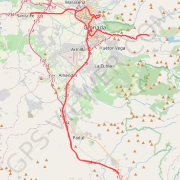
RDE_09_GRENADE_CITY_03
Entre Pinos Genil et Padul.
- Distance: 50.8 mi
- Elevation gain: 3,678 ft
- Maximum elevation: 2,779 ft
- Elevation loss: 3,537 ft
- Minimum elevation: 1,909 ft
Interactive map
GPS track profile
About this GPS track
Name: RDE_09_GRENADE_CITY_03 GPS track, route, trail
Coordinates: 36.97360 -3.70931 37.20145 -3.50606
Other GPS tracks
Click on a GPS track to view route, its statistics and profile.
Eurovelo 01 Spain + Portugal
France > Nouvelle-Aquitaine > Pyrénées-Atlantiques > Hendaye
Distance: 1,930.7 mi • Elevation gain: 100,367 ft • Maximum elevation: 4,931 ft
Southern section — European Divide Trail
France > Auvergne-Rhône-Alpes > Drôme > Valence
Distance: 1,506.1 mi • Elevation gain: 139,026 ft • Maximum elevation: 6,578 ft
Southern Section — European Divide Trail
Espagne > Andalousie > Cazorla
Distance: 516.0 mi • Elevation gain: 63,166 ft • Maximum elevation: 7,001 ft
Stage 26: Valence to Saint-Jean-de-Fos — European Divide Trail
France > Auvergne-Rhône-Alpes > Drôme > Valence
Distance: 1,506.1 mi • Elevation gain: 139,026 ft • Maximum elevation: 6,578 ft
Stage 26: Valence to Saint-Jean-de-Fos — European Divide Trail
Distance: 533.8 mi • Elevation gain: 53,930 ft • Maximum elevation: 4,888 ft
RDE_10_V-Motech_Granada
Espagne > Andalousie > Comarca de la Vega de Granada > Pinos Genil
Entre Pinos Genil et Otura.
Distance: 59.6 mi • Elevation gain: 4,724 ft • Maximum elevation: 2,887 ft
Vila do Bispo -> Distrito 4 (495,2 km)
Distance: 811.8 mi • Elevation gain: 75,879 ft • Maximum elevation: 7,001 ft