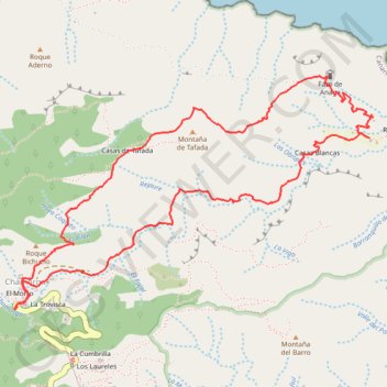
Anaga : Chamorga - Faro de Anago
En boucle depuis Chamorga, par tafada, el faro de Anago, Roque bermejo. #Boucle #meïnaelya
- Distance: 4.8 mi
- Elevation gain: 2,198 ft
- Maximum elevation: 2,008 ft
- Elevation loss: 2,195 ft
- Minimum elevation: 217 ft
- Moving time: 2 h 12 m
- Moving speed: 2.2 mph
- Maximum speed: 4.8 mph
- Total time: 2 h 39 m
- Global speed: 1.8 mph
- Date: 02/08/2018
Interactive map
GPS track profile
About this GPS track
Name: Anaga : Chamorga - Faro de Anago GPS track, route, trail
Coordinates: 28.56833 -16.15972 28.58122 -16.13735
Other GPS tracks
Click on a GPS track to view route, its statistics and profile.
Faro de Anaga
Espagne > Santa Cruz de Ténérife
Benijo - Roque Bermejo. #Randonnée
Distance: 4.4 mi • Elevation gain: 2,211 ft • Maximum elevation: 1,014 ft
Anaga : Chamorga - Faro de Anago
Espagne > Santa Cruz de Ténérife
Distance: 4.8 mi • Elevation gain: 2,156 ft • Maximum elevation: 2,008 ft