Vallvidrera-Montcada
Interactive map
GPS track profile
About this GPS track
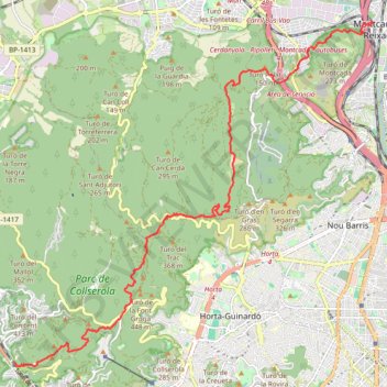
Name: Vallvidrera-Montcada GPS track, route, trail
Coordinates: 41.41958 2.09698 41.48390 2.18590
Other GPS tracks
Click on a GPS track to view route, its statistics and profile.
Southern section — European Divide Trail
France > Auvergne-Rhône-Alpes > Drôme > Valence
Distance: 1,506.1 mi • Elevation gain: 139,026 ft • Maximum elevation: 6,578 ft
1 LUCENA - MONTPELLIER
Distance: 1,842.0 mi • Elevation gain: 96,785 ft • Maximum elevation: 3,438 ft
1 LUCENA - MONTPELLIER
Espagne > Andalousie > Lucena
Distance: 1,842.0 mi • Elevation gain: 96,785 ft • Maximum elevation: 3,438 ft
Stage 26: Valence to Saint-Jean-de-Fos — European Divide Trail
France > Auvergne-Rhône-Alpes > Drôme > Valence
Distance: 1,506.1 mi • Elevation gain: 139,026 ft • Maximum elevation: 6,578 ft
Barcelonne
Espagne > Haut-Ampurdan > Llançà
Barcelonne
Distance: 824.8 mi • Elevation gain: 102,241 ft • Maximum elevation: 5,692 ft
Stage 26: Valence to Saint-Jean-de-Fos — European Divide Trail
France > Auvergne-Rhône-Alpes > Drôme > Valence
Distance: 1,012.7 mi • Elevation gain: 101,184 ft • Maximum elevation: 6,578 ft
OziCE Track Log File- filtered
France > Occitanie > Pyrénées-Orientales > Banyuls-sur-Mer
OziCE Track Log File- filtered
Distance: 907.8 mi • Elevation gain: 118,281 ft • Maximum elevation: 5,715 ft
Monday Afternoon Flight
Espagne > Îles Baléares > Palma > Son Banya
Distance: 391.4 mi • Elevation gain: 87,385 ft • Maximum elevation: 8,478 ft
Santa Susana, Cardedeu, Castellbell i Vilar, Prades, Torto
Espagne > Catalogne > Maresme > Santa Susanna
Distance: 252.4 mi • Elevation gain: 40,023 ft • Maximum elevation: 3,770 ft