Wawgoulzat
Interactive map
GPS track profile
About this GPS track
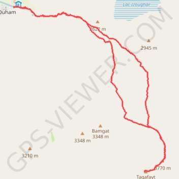
Name: Wawgoulzat GPS track, route, trail
Coordinates: 31.65455 -6.30294 31.70557 -6.24784
Other GPS tracks
Click on a GPS track to view route, its statistics and profile.
Maroc en boucle depuis Tanger
Maroc > pachalik de Tanger > Tanger
Distance: 1,882.0 mi • Elevation gain: 89,413 ft • Maximum elevation: 7,549 ft
Midelt - Marrakech
Maroc > Pachalik de Midelt > Midelt
VTT. En aller simple entre Midelt et Marrakech. #VTT
Distance: 641.7 mi • Elevation gain: 38,638 ft • Maximum elevation: 8,694 ft
Marruecos Junio 2019. De Berguent a Esmara
Maroc > Pachalik de Ain Bni Mathar > Ain Bni Mathar
Distance: 1,411.5 mi • Elevation gain: 38,770 ft • Maximum elevation: 4,770 ft
Maroc 2018
Depuis Marrakech.
Distance: 1,027.6 mi • Elevation gain: 43,786 ft • Maximum elevation: 7,260 ft