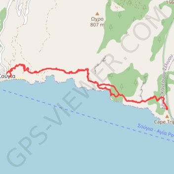
De Sougia à Profitis Ilias
Randonnée en aller-retour depuis Sougia. #Randonnée
- Distance: 9.8 mi
- Elevation gain: 3,153 ft
- Maximum elevation: 1,191 ft
- Elevation loss: 3,173 ft
- Minimum elevation: 0 ft
- Moving time: 5 h 16 m
- Moving speed: 1.9 mph
- Maximum speed: 4.0 mph
- Total time: 6 h 50 m
- Global speed: 1.4 mph
- Date: 07/19/2012
Interactive map
GPS track profile
About this GPS track
Name: De Sougia à Profitis Ilias GPS track, route, trail
Coordinates: 35.23949 23.81113 35.25233 23.86738
Other GPS tracks
Click on a GPS track to view route, its statistics and profile.
Les gorges d'Agria Irini
Grèce > Région Crète > Περιφερειακή Ενότητα Χανίων
Randonnée pédestre. En aller simple. #Randonnée
Distance: 11.6 mi • Elevation gain: 3,596 ft • Maximum elevation: 3,560 ft