Douvres, campagne, falaises
Interactive map
GPS track profile
About this GPS track
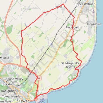
Name: Douvres, campagne, falaises GPS track, route, trail
Start: Athol Terrace, Dover, Douvres, Kent, Angleterre, CT16 1LT, Royaume-Uni (51.12686 1.32737)
Coordinates: 51.12655 1.30980 51.20285 1.38716
Other GPS tracks
Click on a GPS track to view route, its statistics and profile.
1: Canterbury – Dover (Developed)
Royaume-Uni > Angleterre > Kent > Cantorbéry
Developed
Distance: 21.6 mi • Elevation gain: 1,398 ft • Maximum elevation: 423 ft
01: Canterbury – Dover (Developed)
Royaume-Uni > Angleterre > Kent > Cantorbéry
Developed
Distance: 21.0 mi • Elevation gain: 778 ft • Maximum elevation: 420 ft
VF-01-1 Via Francigena - 01 part Great Britain
Royaume-Uni > Angleterre > Kent > Cantorbéry
Distance: 47.8 mi • Elevation gain: 1,729 ft • Maximum elevation: 413 ft