Paradore Guajara Paradore
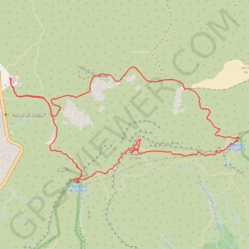
Interactive map
GPS track profile
About this GPS track
Name: Paradore Guajara Paradore GPS track, route, trail
Start: TF-21, La Orotava, Santa Cruz de Ténérife, Îles Canaries, Espagne (28.22450 -16.62746)
End: TF-21, La Orotava, Santa Cruz de Ténérife, Îles Canaries, Espagne (28.22455 -16.62744)
Coordinates: 28.21352 -16.62747 28.22578 -16.59961
Other GPS tracks
Click on a GPS track to view route, its statistics and profile.
LONG TRAIL GR - 131 TENERIFE (CANARY ISLANDS) GR131 GR 131|trackspotting.com
Spain > El Rosario > La Esperanza
Distance: 54.5 mi • Elevation gain: 14,557 ft • Maximum elevation: 7,887 ft
Randonnée du Guadjara (Ténérife)
Distance: 6.7 mi • Elevation gain: 2,408 ft • Maximum elevation: 8,888 ft
Trail Planner Map
Distance: 6.3 mi • Elevation gain: 2,484 ft • Maximum elevation: 8,881 ft