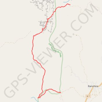
Parc Isalo - Depuis le canyon Maki vers piscine Naturelle & Ranohira
Randonnée pédestre. En aller simple. #Randonnée
- Distance: 9.6 mi
- Elevation gain: 2,293 ft
- Maximum elevation: 3,602 ft
- Elevation loss: 1,877 ft
- Minimum elevation: 2,297 ft
- Moving time: 5 h 55 m
- Moving speed: 1.6 mph
- Maximum speed: 3.4 mph
- Total time: 8 h 51 m
- Global speed: 1.1 mph
- Date: 10/02/2015
Interactive map
GPS track profile
About this GPS track
Name: Parc Isalo - Depuis le canyon Maki vers piscine Naturelle & Ranohira GPS track, route, trail
End: Parking Mangily, N 7, Ranohira, Ihorombe, Province de Fianarantsoa, Madagascar (-22.56218 45.38473)
Coordinates: -22.56682 45.35820 -22.48722 45.39324
Other GPS tracks
Click on a GPS track to view route, its statistics and profile.
Randonnée dans le parc de l'Isalo à Madagascar
Madagascar > Ihorombe > Ranohira le Vieux
Randonnée pédestre. En aller simple. #Randonnée
Distance: 7.7 mi • Elevation gain: 2,185 ft • Maximum elevation: 3,599 ft