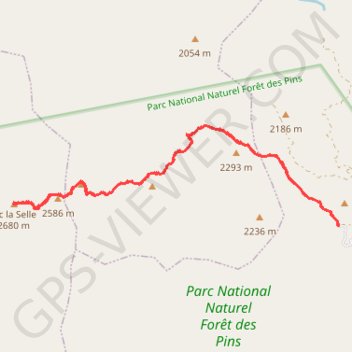
Pic de la Selle
Randonnée pédestre. En aller-retour. #Randonnée
- Distance: 11.5 mi
- Elevation gain: 3,245 ft
- Maximum elevation: 8,770 ft
- Elevation loss: 3,235 ft
- Minimum elevation: 6,640 ft
- Moving time: 5 h 45 m
- Moving speed: 2.0 mph
- Maximum speed: 4.8 mph
- Total time: 8 h 8 m
- Global speed: 1.4 mph
- Date: 04/04/2015
Interactive map
GPS track profile
About this GPS track
Name: Pic de la Selle GPS track, route, trail
Coordinates: 18.35638 -71.97675 18.37390 -71.91688