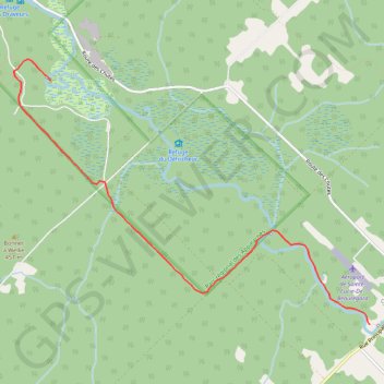
Parc Régional des Appalaches - 1er jour
Randonnée entre Sainte-Lucie-de-Beauregard et Saint-Adalbert. #Randonnée
- Distance: 4.2 mi
- Elevation gain: 213 ft
- Maximum elevation: 1,302 ft
- Elevation loss: 187 ft
- Minimum elevation: 1,188 ft
- Moving time: 2 h 34 m
- Moving speed: 1.6 mph
- Maximum speed: 3.0 mph
- Total time: 3 h 2 m
- Global speed: 1.4 mph
- Date: 05/21/2011
Interactive map
GPS track profile
About this GPS track
Name: Parc Régional des Appalaches - 1er jour GPS track, route, trail
Coordinates: 46.73503 -70.08041 46.76137 -70.02897
Other GPS tracks
Click on a GPS track to view route, its statistics and profile.