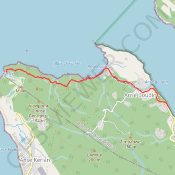
Randonnée de Anse Lazio à Anse Georgette aux Seychelles
Randonnée pédestre. En aller simple. Île de Praslin. Océan Indien. #Randonnée #Praslin #Seychelles
- Distance: 3.0 mi
- Elevation gain: 594 ft
- Maximum elevation: 259 ft
- Elevation loss: 623 ft
- Minimum elevation: 0 ft
- Moving time: 1 h 20 m
- Moving speed: 2.2 mph
- Maximum speed: 26.8 mph
- Total time: 2 h 42 m
- Global speed: 1.1 mph
- Date: 04/07/2015
Interactive map
GPS track profile
About this GPS track
Name: Randonnée de Anse Lazio à Anse Georgette aux Seychelles GPS track, route, trail
End: Anse Boudin, Baie Saint Anne District, Praslin group, Seychelles (-4.30157 55.71503)
Coordinates: -4.30157 55.68167 -4.29347 55.71503
Other GPS tracks
Click on a GPS track to view route, its statistics and profile.
Randonnée de Anse Lazio à Anse Georgette aux Seychelles
Seychelles > Praslin group > Baie Saint Anne District
Distance: 3.0 mi • Elevation gain: 594 ft • Maximum elevation: 259 ft