Islande - Stöng - Gjain
Randonnée pédestre. #Randonnée
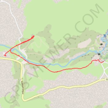
- Distance: 1.1 mi
- Elevation gain: 62 ft
- Maximum elevation: 692 ft
- Elevation loss: 138 ft
- Minimum elevation: 594 ft
Interactive map
GPS track profile
About this GPS track
Name: Islande - Stöng - Gjain GPS track, route, trail
Start: Stangarvegur, Skeiða- og Gnúpverjahreppur, Suðurland, Islande (64.14915 -19.73658)
End: Stöng, Stangarvegur, Skeiða- og Gnúpverjahreppur, Suðurland, Islande (64.14969 -19.75657)
Coordinates: 64.14821 -19.75657 64.15139 -19.73658
Other GPS tracks
Click on a GPS track to view route, its statistics and profile.
Islande Cascade Haifoss et Granni
Islande > Skeiða- og Gnúpverjahreppur
Randonnée pédestre. En aller-retour. #Randonnée
Distance: 12.0 mi • Elevation gain: 1,299 ft • Maximum elevation: 968 ft